|
(接上篇)
未来工作
未来的研究方向可能包括探索如何利用深度学习技术模拟热带气旋的关键物理机制,以及如何进一步改进TCND数据集以更好地满足研究人员的需求。此外,结合TCNM与其他擅长预测热带气旋路径的方法(如PanguWeather模型和官方气象机构的其他方法)可能是未来的一个研究方向,这将有助于开发出能够更有效地利用TCND数据的更优模型,从而提高路径和强度预测的准确性。
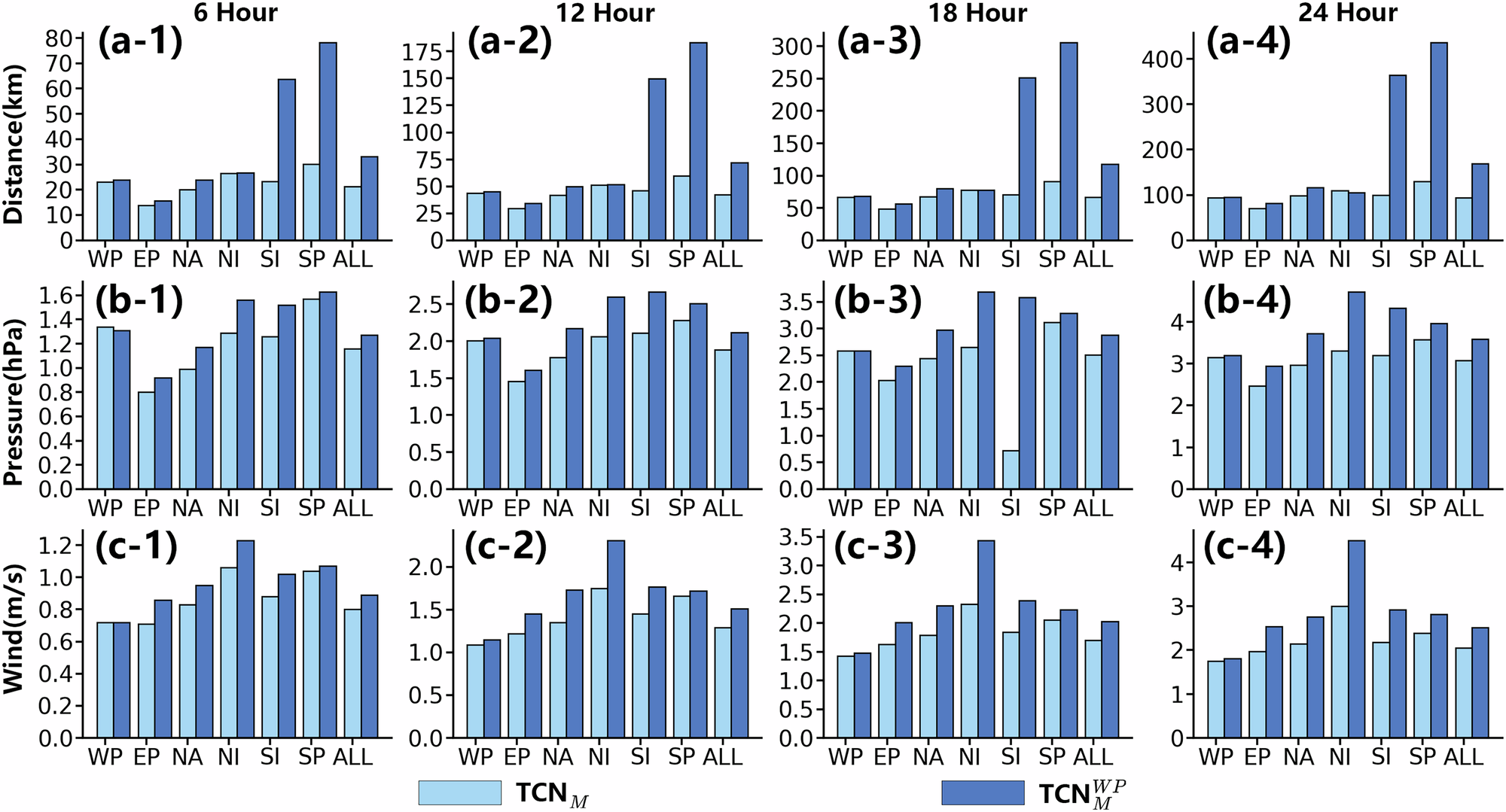
The sea areas include Western North Pacific (WP), Eastern North Pacific (EP), North Atlantic (NA), North Indian (NI), South Indian (SI), and South Pacific (SP). ALL means the average errors of all the six sea areas. Sub-figure (a-1, 2, 3, 4) show the performance of our model on tropical cyclone (TC) track prediction. Sub-figure (b-1, 2, 3, 4) and (c-1, 2, 3, 4) show the performance of our model on TC intensity prediction. The TropiCycloneNet Model (TCNM) means that our model is trained on all the six sea areas. The means that only the data of WP are used for training our model. Metrics Distance, Pressure, and Wind are introduced in the section titled ‘Metrics’. Best view in color. Source data are provided as a Source Data file.
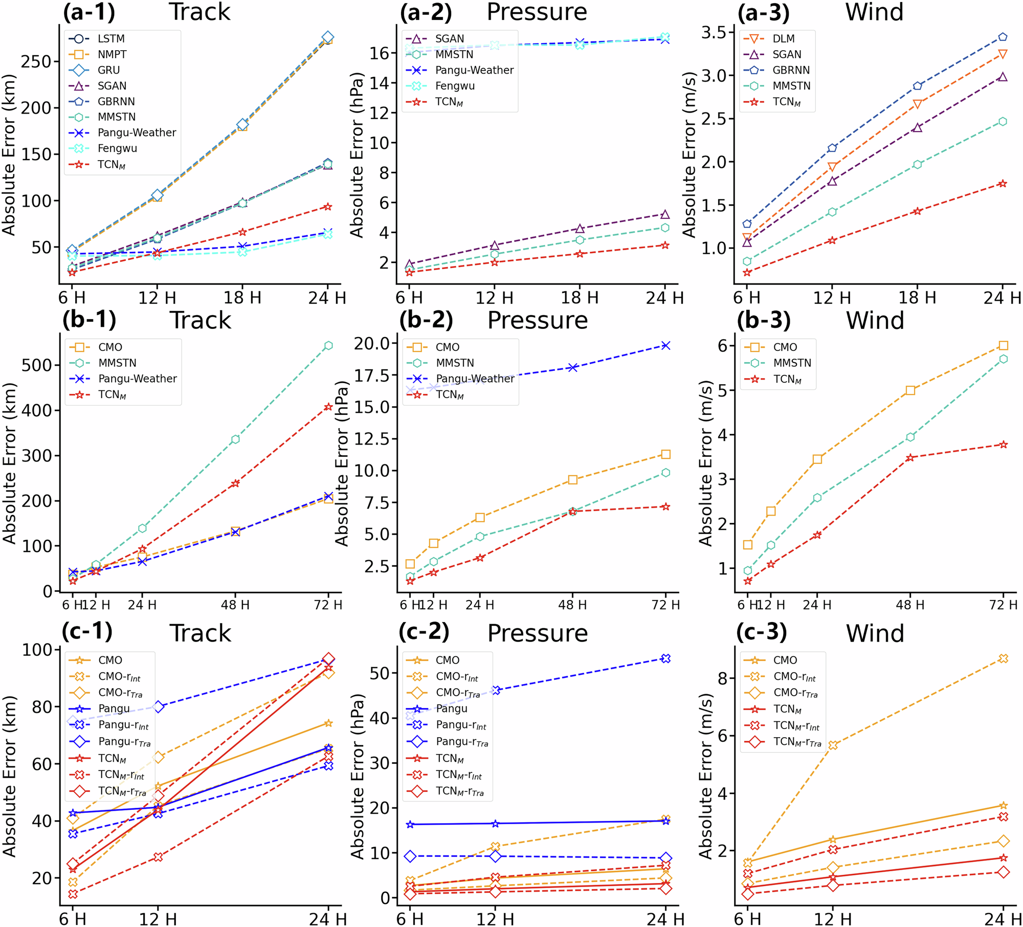
The comparative results are based on Western North Pacific (WP) sea area data, as most of the comparative methods only provide performance results for the WP region. Sub-figures (a-1, a-2, a-3) present the average absolute error comparisons of tropical cyclone (TC) predictions among different deep learning methods. Sub-figures (b-1, b-2, b-3) show the long-term forecasting (6-72 h) capabilities of TCNM. Sub-figures (c-1, c-2, c-3) demonstrate the performance of TCNM during rapid changes in TC track or intensity compared to its overall performance on the entire dataset. In these sub-figures, The three solid lines in the represent the results of Chinese Central Meteorological Observatory (CMO), Pangu-Weather, and TCNM on the complete test set, respectively. CMO-rInt, Pangu-rInt, and TCNM-rInt represent the results of CMO, Pangu-Weather, and TCNM on rapid intensifying TC cases, respectively. CMO-rTra, Pangu-rTra, and TCNM-rTra represent the results of CMO, Pangu-Weather, and TCNM on curving TC cases, respectively. Best viewed in color. Source data are provided as a Source Data file.
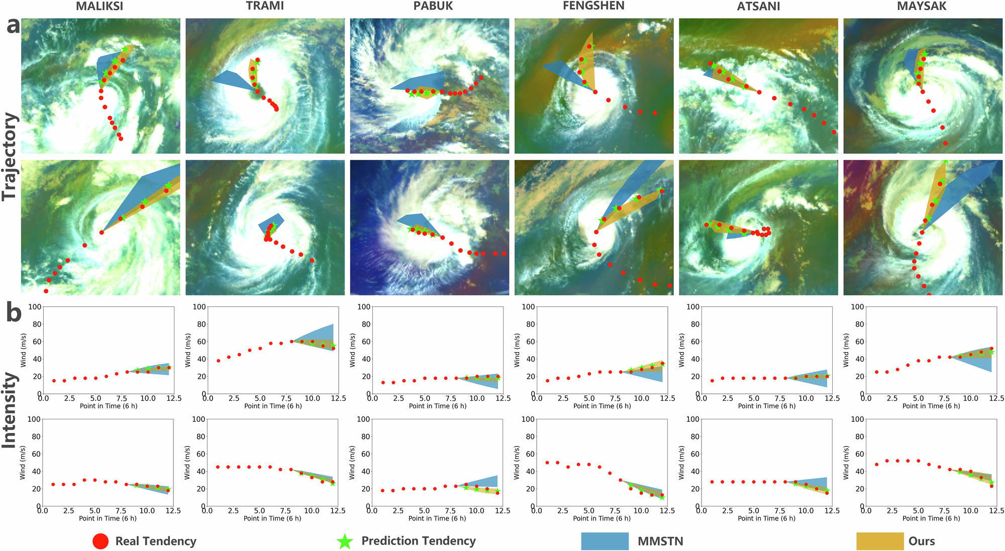 Examples of track and intensity predictions from 6 h to 24 h and the comparison between our method and previous deep learning model (MMSTN) on the potential predictions for six tropical cyclones: MALIKSI (2018, severe tropical storm, Summer), TRAMI (2018, super typhoon, Summer), PABUK (2019, severe tropical storm, Winter), FENGSHEN (2019, strong typhoon, Summer), ATSANI (2020, typhoon, Autumn), and MAYSAK (2020, super typhoon, Summer). Sub-figure a shows the track prediction performance of these two models and Sub-figure b shows the intensity prediction performance of these two models. Best viewed in color.
以上是对文章的详细解读,如有不当之处欢迎批评指出。 | 

 发表于
发表于